
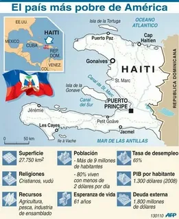
It is one of the most searched geography questions about the Caribbean, and it confuses more people than you would expect. Haiti gets guessed as South American, African, even as a place somewhere in the Pacific. None of those guesses survive a look at a real map. This guide settles it properly, with the island, the neighbours, the distances and the reasons, so you never have to guess again.
The short answer first
Haiti is in the Caribbean, in North America. That is the whole answer, and everything else in this article is just helping you picture it properly.
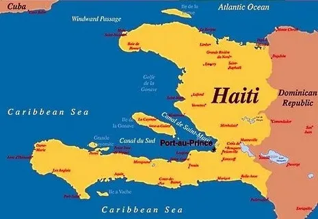
Picture the map of North America. Now let your eye drop down past Florida, past Cuba, and into the warm blue water of the Caribbean Sea. There, on the western side of a large island called Hispaniola, sits Haiti. It shares that one island with the Dominican Republic, which takes up the eastern side. Haiti has the Atlantic Ocean to its north, the Caribbean Sea to its south and west, Cuba about 50 miles away to the west, and Jamaica to the southwest.
So when a quiz, a school assignment, or a form asks which continent Haiti belongs to, the answer is North America. Not South America. Not Africa. North America — even though Haiti never touches the North American mainland at all. Island countries work that way, and by the end of this page you will be able to find Haiti on a blank map in about ten seconds, and explain exactly why it counts as North American.
Haiti at a glance
Before the long explanation, here are the facts that pin Haiti down. Keep this table open in your mind while you read, because almost every confusion about Haiti’s location comes from missing one of these simple details.
| Detail | Fact |
| Continent | North America |
| Region | Caribbean, Greater Antilles |
| Island | Hispaniola, western third |
| Capital and largest city | Port-au-Prince |
| Coordinates | 19 00 N, 72 25 W |
| Total area | 27,750 sq km (10,714 sq mi) |
| Only land neighbour | Dominican Republic, to the east |
| Land border | About 376 km (234 miles) |
| Coastline | 1,771 km (1,100 miles) |
| Oceans and seas | Atlantic Ocean north, Caribbean Sea south and west |
| Highest point | Pic la Selle, 2,674 m (8,773 ft) |
| Official languages | Haitian Creole and French |
| Currency | Gourde |
| Time zone | Eastern Time, UTC-5, UTC-4 in daylight saving |
Two lines in that table do most of the work. The first is the island. Haiti is not a mainland country you can drive into from Mexico or Canada. The second is the region. In geography, the Caribbean is not treated as a continent of its own. It is a subregion of North America, in the same way that Central America is. Once you accept those two points, the rest falls into place very easily.
Start with the island, not the country
Most people go wrong because they look for Haiti as if it were a block of land on a continent. It is not. Haiti is an island country, so the right way to find it is in two steps. First find the island. Then split the island.
The island is Hispaniola. At about 76,192 square kilometres, or 29,418 square miles, Hispaniola is the second-largest island in the Caribbean, behind only Cuba, and the most populous island in the West Indies. It sits right in the middle of the Greater Antilles, the chain of big islands across the northern Caribbean. From west to east, that chain runs Cuba, then Hispaniola, then Puerto Rico, with Jamaica tucked just south of Cuba. If you can picture those four big islands in a row, you already know the neighbourhood Haiti lives in.
Hispaniola is divided between two completely separate countries. The Dominican Republic covers roughly the eastern two-thirds, about 48,445 square kilometres. Haiti covers the western third, about 27,750 square kilometres. Some geography sources describe Haiti’s share more precisely as the western three-eighths of the island. Either way, the picture is the same. One island, two nations, and a single land border running roughly north to south between them.
Christopher Columbus landed on Hispaniola in 1492 and named it La Isla Espanola, which became Hispaniola in English. It was the site of the first European settlements in the Americas. That history matters for location questions too, because old maps and old books sometimes call the whole island Santo Domingo, and sometimes call the whole island Haiti. The Indigenous Taino name for the land was Ayiti, which means land of mountains. Modern Haiti took its name from that word, and as you will see, the name fits the terrain almost perfectly.
Why Haiti is in North America if it is an island
This is the part that trips up students, and honestly, plenty of adults too. If Haiti is surrounded by water, far from the United States, Canada and Mexico, how can it be in North America?
The answer is that continents, in the way geography is taught and in the way world organisations divide the planet, include their nearby islands. North America is not just the mainland block. It includes Greenland in the far north, the countries of Central America down to Panama, and the island nations of the Caribbean. Haiti falls in that last group. The United Nations style of dividing the world, which most atlases and textbooks follow, places the Caribbean inside North America as one of its subregions. Haiti is listed under the Caribbean, and the Caribbean is listed under North America.
Think of it the same way you think of other island countries. Nobody argues that Iceland stops being European because it is surrounded by the Atlantic, or that Japan is not in Asia because you cannot walk there from China. Islands are grouped with the continent they sit closest to and share a geological and regional setting with. Haiti sits on the Caribbean Plate side of the Greater Antilles, in the sea that washes the southeastern edge of North America. There is no other continent it could sensibly belong to. South America begins much further south, across the Caribbean Sea, where Colombia and Venezuela sit. Haiti is hundreds of miles north of that coast.
There is also a useful distinction to learn here. Geographers sometimes talk about North America the continent, and sometimes about North America the region in a narrower political sense, meaning just the United States, Canada and Mexico. In everyday news, people often use the phrase that narrower way, which is why a sentence like Haiti is in North America can sound strange at first. In the full geographical sense, the one used for continents, maps, quizzes and school work, Haiti is North American without question.
Haiti’s neighbours in every direction
The fastest way to really fix a country in your mind is to walk around it, direction by direction. Haiti rewards that exercise, because almost every side tells you something different.
East: the Dominican Republic and then Puerto Rico
To the east, Haiti meets its only land neighbour, the Dominican Republic. The border between them runs about 376 kilometres, from the Atlantic coast in the north down to the Caribbean coast in the south. Cross that line and the language changes from Haitian Creole and French to Spanish, the landscape on the eastern side is generally greener and less steep in the lowlands, and you are in a different country with a different history, even though you never left the island. Keep going east across the Mona Passage and you reach Puerto Rico, the next big island in the Greater Antilles chain.
West: Cuba across the Windward Passage
To the west, Haiti looks across the Windward Passage to Cuba. Britannica puts Cuba at about 50 miles, roughly 80 kilometres, west of Haiti’s northern peninsula. Other references give the narrowest Cuba to Haiti gap as about 48 miles. Either measurement makes the same point. On a clear mental map, Cuba and Haiti are close neighbours separated by an important shipping strait that connects the Atlantic Ocean with the Caribbean Sea. Ships heading for the Panama Canal from the United States East Coast and Europe have used that passage for generations, which gave this corner of the Caribbean a strategic importance far bigger than Haiti’s small size suggests.
North: the Atlantic Ocean and the Bahamas
Haiti’s northern coast faces the Atlantic Ocean, not the Caribbean Sea. That surprises people who assume the whole country is Caribbean on every side. North of Haiti, across the water, lie the Bahamas and the Turks and Caicos Islands, and beyond them, Florida. Haiti’s northern port city, Cap-Haitien, was a major city in the colonial era precisely because of that Atlantic-facing position and the trade routes that passed along it.
South and southwest: the Caribbean Sea and Jamaica
Haiti’s southern coast faces the open Caribbean Sea. To the southwest, about 120 miles or 190 kilometres west of Haiti’s southern peninsula by Britannica’s measurement, sits Jamaica. The water between them is the Jamaica Channel. South of Haiti, across a wide stretch of Caribbean water, the next landfall is the northern coast of South America, in Colombia. That long stretch of sea is exactly why Haiti belongs to the northern continent and not the southern one. It is grouped with the islands above it, not the continent far below it.
| Direction from Haiti | What you find | Rough distance or note |
| East | Dominican Republic, then Puerto Rico | Only land border, about 376 km |
| West | Cuba, across the Windward Passage | About 50 miles (80 km) |
| Southwest | Jamaica, across the Jamaica Channel | About 120 miles (190 km) |
| North | Atlantic Ocean, Bahamas, then Florida | Northern coast is Atlantic-facing |
| South | Caribbean Sea, then Colombia far beyond | No near neighbour to the south |
Two countries, one island: Haiti and the Dominican Republic
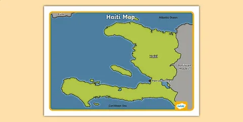
Sharing an island sounds simple until you try to picture daily life on it. Haiti and the Dominican Republic share land, rivers that cross the border, mountain ranges that ignore the border, and weather systems that hit both countries. They do not share a language, a colonial history, or, for most of their history, a government.
The split goes back to colonial times. Spain controlled Hispaniola first, then French settlers and pirates established themselves in the west, and in 1697 Spain formally ceded the western portion to France. That French colony, Saint-Domingue, became Haiti. The east remained Spanish and eventually became the Dominican Republic. The modern border is the product of that old colonial division, tidied and argued over in the centuries since, rather than a natural feature. Mountains and rivers mark parts of it, but in many places it is simply a line on the land.
In 1804, after the Haitian Revolution, Haiti became independent from France. It was the second country in the Americas, after the United States, to free itself from colonial rule, the first free Black republic, and the only country in history founded by a successful revolt of enslaved people. At one point in the nineteenth century the whole island was united under Haitian rule, from 1822 to 1844, before the east broke away and formed the Dominican Republic as it is known today. That shared and divided past is why a location article like this one cannot really separate geography from history. The line down the middle of Hispaniola is a historical decision that geography still lives with.
For a traveller or a student reading a map, the practical points are these. Haiti is the smaller, western, Creole and French speaking country. The Dominican Republic is the larger, eastern, Spanish speaking country. Haiti covers about 27,750 square kilometres. The Dominican Republic covers about 48,445 square kilometres. Haiti, however, is extremely densely populated for its size, with a population estimated at roughly 11 to 12 million people in recent estimates. That makes it the most populous country in the Caribbean, even though Cuba and the Dominican Republic are both larger in land area. Treat any single population figure as an estimate, because counts and projections vary by source and year.
Inside Haiti: the shape of the country
Zoom in from the island to Haiti itself, and the shape is the next thing to learn. Haiti does not look like a neat block. It looks a little like a crab claw, or a letter C opening to the west, formed by two long peninsulas reaching out into the sea.
The northern peninsula points west toward Cuba. The southern peninsula points west too, toward Jamaica. Between those two arms sits the Gulf of Gonave, a large bay that cuts deep into Haiti’s western side. Right on the shore of that gulf, roughly where the two arms begin, sits Port-au-Prince, the capital and largest city. Its position was not an accident. The gulf offered sheltered water, a port, and access inland, and the city, founded by the French in 1749, grew into the country’s political, economic and cultural centre.
Haiti also includes smaller islands of its own. The most important is Ile de la Gonave, sitting inside the gulf of the same name, clearly visible on any detailed map just west of Port-au-Prince. Others include Tortue Island, or Tortuga, off the northern coast, famous in pirate history, plus Ile-a-Vache off the southern coast and Grande Caye. When sources describe Haiti, they usually mean the mainland part of Hispaniola plus these smaller islands together.
The main cities follow the coast, as island geography usually forces them to. Cap-Haitien anchors the north coast. Gonaives sits on the Gulf of Gonave coast north of the capital. Saint-Marc and Leogane lie along the western shore. Les Cayes and Jacmel serve the southern peninsula. The interior, by contrast, is mountainous and harder to cross, which is why coastal cities have always carried so much of the country’s trade and population. The largest concentrations of people are near the coastal areas, even though settlement is spread fairly evenly across the country as a whole.
Land of mountains is not just a nickname
Remember that Taino word, Ayiti, land of mountains. Open a physical map of Haiti and you will see why the name stuck. The CIA World Factbook describes Haiti’s terrain in four blunt words: mostly rough and mountainous. About two-thirds of the country sits well above the lowlands, and mountain ranges alternate with narrow plains and valleys where most farming and town life happen.
Haiti’s highest point is Pic la Selle, at 2,674 metres in the Factbook’s listing, about 8,773 feet, near the border with the Dominican Republic in the southeast. Other listings round the same peak to 2,680 metres, so do not worry if you see either figure. The lowest point is sea level on the Caribbean coast. The longest river is the Artibonite, which rises in the Dominican Republic, crosses into Haiti, and flows into the Gulf of Gonave. It waters the Artibonite Valley, the country’s most important rice growing plain. The largest lake is Etang Saumatre, a brackish lake on the border plain in the east.
The climate follows from the location and the mountains together. Haiti is tropical. Port-au-Prince is hot all year, averaging roughly 23 to 31 degrees Celsius in January and 25 to 35 degrees in July, with two rainy seasons, roughly April to June and October to November. The eastern mountains cut off some of the trade winds, leaving parts of the east noticeably drier and even semiarid. Altitude softens the heat in the highlands, which is why hill towns above the capital have long been prized as cooler escapes from the coastal plain.
That same position, in the middle of the Atlantic hurricane belt, brings the hard side of Caribbean geography. Haiti is exposed to severe storms in the season that runs roughly from June to October, as well as periodic flooding, droughts and earthquakes. The 2010 earthquake, centred near the capital, is the disaster most people outside Haiti know by date, but it was one event in a long pattern shaped by the country’s place on a fault system running through Hispaniola and in the path of Atlantic storms. Location explains a great deal of Haiti’s story, in good ways and in hard ones.
How far is Haiti from the United States?
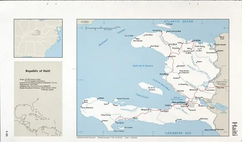
For American readers, and for the many Haitian families split between Haiti and the United States, this is often the real question hiding behind the search. The answer is: closer than most people guess.
The straight-line flight distance from Miami to Port-au-Prince is about 707 miles, roughly 1,138 kilometres. That is shorter than the distance from Miami to New York. In flying terms it is a short hop south and slightly east, over the Bahamas and past Cuba’s eastern tip, down to Hispaniola. Haiti also keeps Eastern Time, UTC minus five in standard time and UTC minus four during daylight saving, the same clock as Miami and New York for most practical purposes. When it is noon in Miami, it is noon in Port-au-Prince. Few facts make Haiti’s North American position feel more real than that one. It does not just sit near the United States on the map. It lives in the same time band, the same sea, and the same weather system.
That closeness has shaped everything from trade to migration to music and food in South Florida, where a large Haitian diaspora lives. It also explains why Haiti appears so often in United States news. A country 700 miles from Florida, sharing the Caribbean and the Atlantic hurricane season, is never really far away, whatever a flat world map might make you feel when your eye slides past the small islands.
The confusions, cleared up one by one
Search data around Haiti is full of the same handful of mix-ups. Let us deal with them plainly, because each one teaches you something real about how regions work.
Is Haiti in South America?
No. South America is the continent below the Caribbean Sea, starting with Colombia and Venezuela. Haiti is well north of that coast, in the island chain that belongs to North America. The confusion usually comes from the phrase Latin America, which groups Spanish, Portuguese and French speaking countries together for cultural and historical reasons. Haiti is part of Latin America in that cultural sense, because of its French and Creole roots, and so are Mexico and most of Central and South America. Latin America is a language and history grouping. It is not a continent, and it does not move Haiti south.
Is Haiti in Africa?
No, and this confusion deserves a respectful answer rather than a dismissive one. Most Haitians descend from Africans who were brought to Hispaniola by force during the slave trade, and African heritage runs deep in Haitian language, religion, music and food. Vodou, for example, blends West and Central African spiritual traditions with Catholic elements. That cultural connection to Africa is real and central to Haitian identity. Geographically, though, Haiti is in the Americas, across the Atlantic Ocean from Africa, thousands of miles away. Ancestry and location are two different things, and Haiti holds both truths at once.
Is Haiti in Central America?
Not in the mainland sense. Central America usually means the narrow land bridge of countries from Guatemala and Belize down to Panama, sometimes counted from Mexico. Haiti is an island east of that bridge, across the Caribbean Sea. Some broad regional schemes group Central America and the Caribbean together for statistics, which is why the CIA’s map references for Haiti read Central America and the Caribbean. That is a filing label for a reference book, not a claim that Haiti sits on the Central American mainland. In continent terms, both Central America and the Caribbean belong to North America anyway, so the end answer stays the same.
Is Haiti a US territory?
No. Haiti has been an independent country since 1804. It is not a United States territory like Puerto Rico or the US Virgin Islands, its eastern Caribbean neighbours. United States forces did occupy Haiti from 1915 to 1934, a major chapter in its history, but occupation is not ownership, and Haiti has remained a sovereign republic. If you are filling in a form that lists countries, Haiti gets its own line, its own country code HT, and its own internet domain, .ht.
Haiti beside its Caribbean neighbours
A comparison helps when the individual facts will not stick. Here is Haiti next to the three neighbours Americans most often place it beside. Areas are standard reference figures, rounded where sources differ slightly.
| Feature | Haiti | Dominican Republic | Cuba | Jamaica |
| Position | Western Hispaniola | Eastern Hispaniola | Largest island, west of Haiti | South of Cuba, southwest of Haiti |
| Area | 27,750 sq km | 48,445 sq km | About 109,880 sq km | About 10,991 sq km |
| Capital | Port-au-Prince | Santo Domingo | Havana | Kingston |
| Main languages | Haitian Creole, French | Spanish | Spanish | English, Jamaican Patois |
| Continent | North America | North America | North America | North America |
| Island group | Greater Antilles | Greater Antilles | Greater Antilles | Greater Antilles |
Notice the last two rows. All four countries share them. That is the lesson of this whole article in miniature. The Greater Antilles, the big island group of the northern Caribbean, is part of North America, so every country in it is North American, however different their languages and histories are. Haiti is not an exception to the rule. It is one of the clearest examples of it.
How to find Haiti on any map in ten seconds
Here is a method that works on a classroom wall map, in an atlas, or on a phone with the labels turned off. Teachers are welcome to steal it.
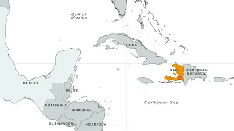
- Find Florida. Put your finger on Miami, at Florida’s southeastern tip.
- Move straight down. You cross a short stretch of water and hit Cuba, the long island running east to west. Slide along Cuba to its eastern end.
- Hop the narrow strait. That hop, across the Windward Passage, lands you on Hispaniola, the next big island east. Puerto Rico is the smaller big island after it, if you need a check that you have gone the right distance.
- Split Hispaniola into thirds. The western third is Haiti. The eastern, larger part is the Dominican Republic. Look for the deep bay cutting into Haiti’s west coast, the Gulf of Gonave, with the capital, Port-au-Prince, on its shore.
That is it. Florida, Cuba, hop, split. Once you have done it twice, you will never lose Haiti again, and you will start noticing how many news maps quietly crop the Caribbean out, which is one reason so many people were never really shown where Haiti is in the first place.
A second memory hook helps with the peninsulas. Haiti has a north arm pointing at Cuba and a south arm pointing toward Jamaica, with the capital tucked into the sheltered water between them. If the island country you are looking at has that two-armed shape on the western side of Hispaniola, you are looking at Haiti.
Why Haiti’s location in North America actually matters
It is fair to ask whether any of this is more than trivia. It is. A country’s position quietly decides a surprising amount of its life, and Haiti is a strong example.
Weather is the most obvious. Sitting in the northern Caribbean puts Haiti directly in the Atlantic hurricane track and on the Enriquillo-Plantain Garden fault system that runs through southern Hispaniola. Floods, storm damage and earthquake risk are not bad luck added on top of geography. In large part, they are geography. Any serious discussion of building standards, farming or disaster planning in Haiti has to start with the map.
Trade and travel follow the same map. The Windward Passage on Haiti’s western doorstep is one of the great sea lanes of the Americas, linking the Atlantic with the Caribbean and, beyond it, the Panama Canal. The Dominican border is Haiti’s only land trade route. And the short air distance to Florida, on the same Eastern clock, ties Haiti tightly to the United States for trade, family travel and remittances, the money Haitians abroad send home, which is a major support for many households.
Regional belonging matters politically too. As a Caribbean and North American country, Haiti is a member of the Caribbean Community, known as CARICOM, works within the Organization of American States, and is grouped with the Americas in the United Nations and in sporting bodies. When Haiti plays in North and Central American and Caribbean football competition, through Concacaf, that is its geography expressed as a fixture list. None of those memberships would make sense if Haiti were placed anywhere else.
Finally, there is a simple matter of respect in getting a country’s location right. Haiti is often talked about at a distance, as a name in a headline. Placing it properly, close to Florida, in a familiar sea, in a familiar time zone, among neighbours most readers can name, shrinks that false distance. It is a nearby North American and Caribbean country with a long, remarkable and difficult history. The map, read honestly, tells you that before any headline does.
Final word
So, where is Haiti in North America? It is in the southeastern part of the continent, out in the Caribbean Sea, on the western third of the island of Hispaniola. The Dominican Republic is its neighbour to the east on the same island, Cuba lies about 50 miles to the west, Jamaica to the southwest, the Bahamas and Florida to the north, with the Atlantic Ocean on its north coast and the Caribbean Sea on its south and west coasts. Its capital is Port-au-Prince, its coordinates are roughly 19 degrees north and 72 degrees west, and it shares Eastern Time with the United States East Coast.
If you remember only one line, remember this one. Find Hispaniola, take the western third, and you have found Haiti, a North American country in every geographical sense that counts.
Frequently asked questions
1. Where is Haiti in North America?
Haiti is in the Caribbean part of North America, in the southeast of the continent. It occupies the western third of the island of Hispaniola, between the Caribbean Sea and the North Atlantic Ocean, east of Cuba and west of the Dominican Republic. Its capital is Port-au-Prince.
2. Is Haiti in North America or South America?
Haiti is in North America. The Caribbean islands belong geographically to North America, not South America. South America starts further south, across the Caribbean Sea, with countries such as Colombia and Venezuela. Haiti is part of Latin America culturally, but Latin America is not a continent.
3. What island is Haiti on, and which country shares it?
Haiti is on Hispaniola, the second-largest island in the Caribbean and part of the Greater Antilles. Haiti takes the western third of the island. The Dominican Republic takes the eastern two-thirds. The two countries share Haiti’s only land border, about 376 kilometres long.
4. What is the capital of Haiti, and where is it?
The capital and largest city is Port-au-Prince. It sits on the Gulf of Gonave, on Haiti’s west coast, roughly between the country’s northern and southern peninsulas. It is the centre of government, the main port and the country’s largest population centre.
5. Which countries and seas are closest to Haiti?
The Dominican Republic borders Haiti to the east. Cuba lies about 50 miles to the west across the Windward Passage. Jamaica is about 120 miles to the southwest. The Bahamas lie to the north. The Atlantic Ocean borders Haiti’s north coast, and the Caribbean Sea borders its south and west coasts.
6. How far is Haiti from the United States?
Haiti is about 707 miles from Miami, Florida, by straight-line air distance to Port-au-Prince, roughly 1,138 kilometres. It is in the Eastern Time Zone, UTC minus five, the same time as Florida and the United States East Coast, with daylight saving taking it to UTC minus four in summer.
7. What are Haiti’s coordinates, area and highest point?
Haiti’s geographic coordinates are about 19 00 N, 72 25 W. Its total area is 27,750 square kilometres, slightly smaller than the US state of Maryland, with 1,771 kilometres of coastline. Its highest point is Pic la Selle at 2,674 metres above sea level.
8. Is Haiti in Africa?
No. Haiti is in the Americas, in the Caribbean. Most Haitians have African ancestry because enslaved Africans were brought to Hispaniola during the colonial period, and African heritage is central to Haitian culture, language and religion. That is a cultural and historical connection, not a geographic one.
9. What languages are spoken in Haiti?
Haiti has two official languages, Haitian Creole and French. Haitian Creole, called Kreyol in the language itself, is the everyday language spoken by virtually everyone. French is used in government, law, education and formal settings. Next door in the Dominican Republic, the main language is Spanish.
10. Why is Haiti called the land of mountains?
The name comes from Ayiti, the Indigenous Taino name for Hispaniola, meaning land of mountains. Haiti revived the name at independence in 1804. It is an accurate description. Most of the country is rough and mountainous, and Haiti is often described as the most mountainous nation in the Caribbean.









Leave a Reply