
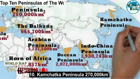
Short answer first: the biggest peninsula in the world is the Arabian Peninsula in western Asia, at roughly 3.1 million square kilometres (about 1.2 million square miles). After it come the Indochinese Peninsula, the Deccan (Indian) Peninsula, and Canada’s Labrador Peninsula. The full ranked list, with the seas on every side and the countries on each one, is below.
A quick note on the search itself, because it is how a lot of readers land here. People type this question in all kinds of ways — biggest penins, largest peninsulas, biggest peninsulas on Earth — and they usually want the same simple thing: a clean ranking they can trust, not three different lists that disagree with each other. So this guide does two jobs. It gives you the ranking, and it explains, honestly, why published areas for the same peninsula sometimes differ. Peninsula boundaries are not like country borders. Nobody surveyed them with a fence. Where a peninsula starts is a judgement call, and geographers do not always make the same call.
What Exactly Is a Peninsula?
A peninsula is a piece of land that sticks out from a larger landmass and is surrounded by water on most of its sides, while staying connected to the mainland on at least one side. That connection is the whole difference between a peninsula and an island. An island is cut off completely. A peninsula never quite lets go.
The word itself tells the story. It comes from the Latin paene, meaning almost, and insula, meaning island — so a peninsula is, literally, an almost-island. It is a neat description, and once you know it, you start seeing peninsulas everywhere on a world map. Florida is one. Italy is one — the famous boot. So is Korea, so is Denmark’s Jutland, and so, on a much grander scale, is the entire southern half of India.
There is no minimum size. A peninsula can be a short, rocky headland you could walk across in an afternoon, or it can be a subcontinent-sized slab of land holding several countries and more than a hundred million people. Size is exactly what this ranking measures, and at the top end, the numbers are honestly hard to picture. The largest entry on this list is almost as large as India. Read that again. A single peninsula, nearly the size of the world’s most populous country.
The Ranking at a Glance: Top 12 Biggest Peninsulas in the World
Here is the full list before we walk through it one by one. Areas are the most widely published figures, rounded sensibly, and the section after the table explains why you may see slightly different numbers on other sites.
| Rank | Peninsula | Area (km²) | Area (sq mi) | Where it is |
| 1 | Arabian Peninsula | 3,100,000 | 1,200,000 | West Asia |
| 2 | Indochinese Peninsula | 2,000,000 | 770,000 | Southeast Asia |
| 3 | Deccan (Indian) Peninsula | 1,900,000 | 800,000 | South Asia — India |
| 4 | Labrador Peninsula | 1,400,000 | 540,000 | Eastern Canada |
| 5 | Anatolian Peninsula | 755,688 | 291,773 | Asian Türkiye |
| 6 | Scandinavian Peninsula | 750,000 | 290,000 | Norway, Sweden, NW Finland |
| 7 | Balkan Peninsula | 666,700 | 257,400 | Southeast Europe |
| 8 | Iberian Peninsula | 583,256 | 225,196 | Spain and Portugal |
| 9 | Antarctic Peninsula | 522,000 | 202,000 | West Antarctica |
| 10 | Taymyr Peninsula | 400,000 | 150,000 | Northern Siberia, Russia |
| 11 | Kamchatka Peninsula | 370,000 | 140,000 | Russian Far East |
| 12 | Korean Peninsula | 220,750 | 85,232 | North and South Korea |
One name is deliberately handled with care in this table: the Somali Peninsula, better known as the Horn of Africa. Depending on where a source draws its inland boundary, it is published at anything from about 750,000 km² for the narrower Somali region to roughly 1.88 million km² for the full Horn — a figure that would place it fourth. It gets its own honest discussion in its section below, rather than a single number pretending to be settled fact.
Why Peninsula Sizes Differ Between Sources
If you compare three websites on this topic, you will probably find three slightly different rankings, and it is tempting to assume somebody is simply wrong. Usually, nobody is. They are measuring slightly different things.
The problem is the neck. Every peninsula narrows, widens, or fades into the mainland somewhere, and there is rarely an official line across that neck. Draw the line generously and the peninsula swallows extra land and climbs the ranking. Draw it tightly and it shrinks. The Arabian Peninsula is so clearly boxed in by seas that everyone agrees on it, which is one reason its number one spot is never seriously challenged. The arguments start further down the list.
The Horn of Africa is the best example. Count only the Somali-inhabited lowlands and you get a mid-sized peninsula. Count the whole Horn — Somalia, the Somali Region of Ethiopia, and the lands reaching toward Djibouti and Eritrea — and it becomes one of the largest land projections on Earth, jutting into the Indian Ocean like a rhino’s horn, which is exactly the shape that gave it its name.
Alaska causes the opposite mistake. Older reference books often list an Alaska Peninsula of about 1.5 million km², which would rank near the top. That figure actually describes most of mainland Alaska, not the Alaska Peninsula itself. The real Alaska Peninsula is the long, narrow, volcanic tail in the southwest that runs out toward the Aleutian Islands — dramatic, wild, full of bears and volcanoes, but only a small fraction of that famous number. This guide uses the corrected understanding, which is why Alaska appears in the honourable mentions rather than near the top.
So treat every area in this article the way geographers do: as a well-supported estimate, not a land-registry measurement. The order of the very top — Arabia first by a huge margin — is solid. The shuffling in the middle is where honest sources can differ.
1. Arabian Peninsula — The Biggest Peninsula in the World
Nothing else is close. At roughly 3.1 million km², the Arabian Peninsula is about one and a half times the size of the second entry on this list, almost as large as India, and roughly four times the size of Texas. It dominates the map of western Asia so completely that the region and the peninsula are nearly the same thing.
Water holds it on almost every side. The Red Sea runs down its west, the Gulf of Aqaba and the Levant mark the northwest, the Persian Gulf (also called the Arabian Gulf) cuts in from the northeast, the Gulf of Oman sits at its eastern corner, and the Arabian Sea washes the entire southern coast. Only the north, through the deserts of Jordan and Iraq, melts into the rest of Asia without a shoreline — and even there, the land connection is mostly empty desert, which makes Arabia feel like an island in practice, not just in shape.
Politically, it holds Saudi Arabia — which takes up most of it — plus Yemen, Oman, the United Arab Emirates, Qatar, Kuwait, and Bahrain just offshore, with southern slices of Jordan and Iraq at its northern edge. Qatar is itself a small peninsula poking off the big one, a peninsula on a peninsula, which students tend to remember long after the exam.
Most of the interior is desert, and not gentle desert either. The Rub’ al Khali, the Empty Quarter in the south, is the largest continuous sand desert on Earth. Yet the edges tell a different story: green mountains in Yemen and Oman that catch monsoon rain, the great port cities of Dubai, Doha, Muscat, and Jeddah, and the oil and gas fields of the Gulf coast that reshaped the world economy in the twentieth century. If any single peninsula changed modern history through sheer geography — sitting between Europe, Africa, and Asia, on top of enormous energy reserves — it is this one.
2. Indochinese Peninsula — Mainland Southeast Asia
Second place belongs to the Indochinese Peninsula, at about 2 million km². The name gives away its position: it is the great block of mainland Southeast Asia sitting between India to the west and China to the north, and generations of mapmakers simply named it for its two giant neighbours.
Myanmar, Thailand, Laos, Cambodia, and Vietnam fill most of it, with the northern part of peninsular Malaysia reaching down its southern tail. The Andaman Sea and the Bay of Bengal wash the west, the South China Sea the east, and the Gulf of Thailand cuts into the middle like a bite — which is why Thailand and Cambodia face each other across a gulf in the centre of the peninsula rather than sharing the long border you might expect.
Where Arabia is dry, Indochina is wet. Monsoon rain, dense forest, and some of the great rivers of Asia — the Mekong, the Irrawaddy, the Chao Phraya, and the Red River — shape everything here. Those rivers built the flat, fertile deltas where most of the peninsula’s roughly 240 million people actually live, farm rice, and crowd into cities like Bangkok, Yangon, Hanoi, Ho Chi Minh City, and Phnom Penh. Geographers sometimes split hairs and treat the long Malay extension in the south as a separate peninsula of its own; counted together as one landmass, as most rankings do, the Indochinese total is what earns second place.
3. Deccan Peninsula — The Triangle That Is Southern India
Third, at about 1.9 million km², is the Deccan — better known to most readers as the Indian Peninsula, because it is quite simply the southern, triangular half of India, pointed like an arrowhead into the Indian Ocean.
Its three coastlines are famous even to people who have never used the word peninsula. The Arabian Sea runs along the west coast, past Mumbai and Goa. The Bay of Bengal runs along the east coast, past Chennai and Visakhapatnam. And the two seas meet at the tip, at Kanyakumari, where you can watch the sun rise over one body of water and set over another on the same day. Few peninsulas advertise their shape so clearly to the naked eye.
Inland, the Deccan is mostly an old, high plateau, edged by two mountain ranges — the Western Ghats, which catch the monsoon and hold some of the richest forests in Asia, and the lower Eastern Ghats. Rivers like the Godavari and the Krishna flow east across it to the Bay of Bengal. Why does this matter for the ranking? Because the Deccan is the reason India is routinely called a subcontinent and a peninsular country at the same time. Both labels are true. India is a distinct geographic unit, and its southern bulk is, by any definition, one of the largest peninsulas on the planet.
The Special Case: Somali Peninsula — The Horn of Africa
Here is where this guide earns its honesty points. The Somali Peninsula, universally nicknamed the Horn of Africa for its rhino-horn shape on the map, is published at wildly different sizes: about 750,000 km² in lists that count only the Somali region narrowly, and up to about 1.88 million km² in lists that count the full Horn. On the generous measure, it would sit fourth in the world. On the narrow measure, it sits around seventh. Both numbers circulate because the inland boundary, fading into the Ethiopian Highlands, is genuinely hard to draw.
It is a dry, tough, beautiful landscape of plateau, thorn bush, and frankincense trees, inhabited for thousands of years by Somali, Oromo, Afar, and other peoples, and tied by trade across the water to Arabia — the peninsula directly opposite it. Look at a map and the two landmasses almost mirror each other across the Gulf of Aden. That is no coincidence of drawing. It is the same rifted geology, slowly pulling apart.
4. Labrador Peninsula — Canada’s Cold Giant
The largest peninsula in North America is one most people could not find quickly, which says more about our habits than its size. The Labrador Peninsula covers about 1.4 million km² of eastern Canada — most of northern Quebec and all of mainland Labrador — making it almost twice the size of Europe’s largest peninsula.
Hudson Bay cuts deep into its west, Hudson Strait runs across its north, the Atlantic Ocean takes the east, and the Gulf of St. Lawrence nicks the southeast corner. In other words, it is water on nearly every side, exactly as a textbook peninsula should be, just at a scale and a latitude that keeps it off postcards.
This is Canadian Shield country: ancient rock, thousands of lakes, spruce forest giving way to tundra, and winters that mean business. It is very sparsely populated, with Quebec and Newfoundland and Labrador sharing it, Indigenous nations — Innu, Cree, Naskapi, and Inuit in the far north of Nunavik and Nunatsiavut — having lived here for millennia, and its rivers now dammed for some of the biggest hydroelectric projects in the world, including the Churchill Falls and James Bay developments. Labrador is the ranking’s quiet giant: fourth on this list, first in almost nobody’s memory. Now it is in yours.
5. Anatolian Peninsula — The Land Bridge Called Asia Minor
At about 755,688 km², the Anatolian Peninsula is the Asian part of Türkiye — everything west of the line where Türkiye meets Georgia, Armenia, Iran, and Iraq. The Romans called it Asia Minor, Minor meaning smaller, which sounds like an insult until you realise it is still larger than France.
Three seas hold it: the Black Sea to the north, the Aegean Sea to the west, and the Mediterranean to the south, with the narrow Bosphorus and Dardanelles straits at its northwest tip, facing Istanbul and Europe across water you could almost shout over. That position — a ready-made bridge between Europe and Asia, and a cork in the bottle between the Black Sea and the Mediterranean — has made Anatolia contested, traded across, and marched over for literally thousands of years, from Hittites and Persians to Greeks, Romans, Byzantines, Seljuks, and Ottomans.
The land itself is a high central plateau ringed by mountains, the Pontic range along the Black Sea and the Taurus along the south, with hot dry summers inland and green, tea-growing slopes in the northeast. Capitals and empires come and go. Bridges on maps tend to stay important, and Anatolia is one of the most important pieces of bridge geography on Earth.
6. Scandinavian Peninsula — Europe’s Largest
Europe’s biggest peninsula, at about 750,000 km², is the Scandinavian Peninsula: mainland Norway and Sweden together, plus the northwestern corner of Finland. It is Europe’s wild north — long, mountainous, and pointed like a club toward the Arctic.
The Norwegian Sea and the North Sea take the west, where Norway’s coast famously dissolves into fjords — deep, glacier-carved inlets that are really the sea reaching far into the peninsula rather than the land reaching out. The Baltic Sea and the Gulf of Bothnia hold the east and southeast, and the Barents Sea the far north, up at the North Cape, where the land finally runs out further north than almost anywhere else on mainland Europe.
One geological detail makes Scandinavia special in this list: it is still rising. The ice sheet that sat on it during the last Ice Age was so heavy that it pressed the crust down, and the land has been springing back ever since the ice melted — in places by close to a centimetre a year, fast enough that harbours built centuries ago now sit inland. A peninsula that is measurably growing taller while you read about it deserves its place in any top ten.
7. Balkan Peninsula — Where Europe Breaks Into Pieces
Southeast Europe, at about 666,700 km², forms the Balkan Peninsula, named after the Balkan Mountains that run through Bulgaria. If Arabia is one land with a handful of states, the Balkans are the opposite: a single peninsula shared, depending on how you draw the northern boundary, by Albania, Bosnia and Herzegovina, Bulgaria, Croatia, Greece, Kosovo, Montenegro, North Macedonia, Serbia, Slovenia, Romania’s coast, and the European sliver of Türkiye.
The Adriatic and Ionian seas wash the west, the Aegean the south and southeast, and the Black Sea the east. That three-sea setting, cut up by mountain ranges in almost every direction, is the geographic seed of the region’s famous complexity. Valleys and coastal plains developed semi-separately for centuries, languages and empires layered over each other, and the peninsula’s southern tip — Greece — splinters at the end into smaller peninsulas of its own, like the Peloponnese, which an ancient canal has nearly turned into an island.
Treat the Balkan area figure as the softest in the top ten, because its northern edge, usually drawn along the Danube and Sava rivers, is a convention rather than a coastline. Move the line, and the peninsula grows or shrinks by a province or two. The character of the place, mountainous and maritime at once, never changes.
8. Iberian Peninsula — Spain, Portugal, and One Very Famous Rock
The Iberian Peninsula, about 583,256 km² in the far southwest of Europe, is mostly Spain, with Portugal running down its Atlantic side like a separate ribbon, small Andorra tucked in the Pyrenees, a sliver of France at the mountains’ edge, and Gibraltar at the southern tip.
The Atlantic Ocean holds its west and north, the Mediterranean Sea its east and south, and the two meet at the Strait of Gibraltar, where the peninsula comes within about 14 kilometres of Africa — close enough to see Morocco on a clear day. Only the Pyrenees connect Iberia to the rest of Europe, and mountains are a weak connection, which is why an old saying claims that Africa begins at the Pyrenees. Unfair, certainly. Geographically suggestive, also yes.
Iberia is mostly a high, dry central plateau, the Meseta, ringed by greener coasts — rainy Galicia, the Mediterranean resorts of the east, the surf beaches of Portugal. From these coasts, Spanish and Portuguese sailors launched the voyages that redrew the world map in the fifteenth and sixteenth centuries. Peninsulas breed sailors for an obvious reason: grow up with the sea on three sides, and the sea starts to look like a road.
9. Antarctic Peninsula — The Biggest Peninsula Nobody Lives On
Every entry so far has cities, languages, and arguments. This one has penguins. The Antarctic Peninsula, about 522,000 km², is the long, curved finger of West Antarctica that reaches up toward South America, ending roughly 1,000 kilometres across the Drake Passage from Cape Horn.
It is surrounded by the Bellingshausen Sea to the west and the Weddell Sea to the east, covered in ice and mountain, and claimed in overlapping slices by Argentina, Chile, and the United Kingdom — claims the Antarctic Treaty politely freezes, in every sense. Nobody lives there permanently. The population is a rotating cast of scientists at research stations, plus large colonies of gentoo, chinstrap, and Adélie penguins along its relatively mild coasts.
Mild is doing heavy work in that sentence, but it is accurate in context: the peninsula is the warmest part of Antarctica, and also one of the fastest-warming places on the planet, which is why its glaciers and ice shelves are watched so closely by climate researchers. On size alone it earns ninth place comfortably — a reminder that the ranking measures land, not people, and that some of Earth’s biggest shapes sit at the ends of the world, almost unvisited.
10. Taymyr Peninsula — The Northernmost Mainland on Earth
At about 400,000 km², the Taymyr Peninsula in Russia’s Krasnoyarsk Krai is not the largest on this list, but it holds a record none of the others can take: its tip, Cape Chelyuskin, is the northernmost point of any continental mainland on Earth. Stand there and there is no more land between you and the North Pole — just the Arctic Ocean.
The Kara Sea lies west of it and the Laptev Sea east, both arms of an ocean that stays ice-locked most of the year. Inland are the Byrranga Mountains, Lake Taymyr — one of the largest lakes in Russia — and tundra grazed by wild reindeer, including one of the largest herds anywhere. The human population is tiny, mostly in small settlements, with the Indigenous Dolgan and Nganasan peoples among its long-standing inhabitants.
Taymyr is what a peninsula looks like at the extreme edge of habitability: enormous, empty, and shaped by ice rather than by trade or war. It also quietly settles a trivia favourite — the northernmost mainland point is not in Canada or Alaska, as many guess, but on this Siberian peninsula most atlases barely label.
11. Kamchatka Peninsula — Russia’s Land of Fire and Bears
Kamchatka, about 370,000 km², hangs down from Russia’s far northeast like a fish on a line, with the Sea of Okhotsk to its west, the Bering Sea to its east, and the open Pacific at its southern tip. From Moscow it is roughly eight time zones away, which is why Russians themselves use Kamchatka the way teachers use the back row of a classroom — as the byword for as far away as it gets.
What it lacks in ranking position it repays in drama. Around 300 volcanoes run down its spine, about 29 of them active, including Klyuchevskaya Sopka, the highest active volcano in Eurasia. Geysers steam in protected valleys, rivers fill with salmon, and the salmon fill with brown bears — Kamchatka holds one of the densest bear populations on Earth. There are no roads connecting it to the rest of Russia. You arrive by plane or ship, or you do not arrive.
Number 12 on this list, just below Kamchatka in size, is the Korean Peninsula, at about 220,750 km² — far smaller than the giants above, but arguably the most politically significant peninsula in the world, divided between North and South Korea across the DMZ, with the Yellow Sea on one side and the Sea of Japan on the other. Size decides this ranking; it does not decide importance, and Korea is the clearest proof.
Honourable Mentions: Famous Peninsulas That Just Miss the Top Ranks
Some of the most famous peninsulas on Earth are nowhere near the top of this list, and that mismatch between fame and size is worth a short tour. Florida, the southeastern finger of the United States, covers roughly 170,000 km² — instantly recognisable on any map, ringed by the Atlantic and the Gulf of Mexico, yet barely a twentieth of Arabia’s size. The Yucatán Peninsula in Mexico, about 197,000 km² of flat limestone holding Cancún, Mérida, and the Maya heartland, separates the Gulf of Mexico from the Caribbean Sea and is actually slightly larger than Florida.
Baja California, Mexico’s other great peninsula, is long and skinny — about 1,250 kilometres from top to tip but only around 143,000 km² in area, a lesson in why length is not size. Italy’s boot, perhaps the most recognisable peninsula shape in the world, is smaller still at roughly 131,000 km², hemmed in by the Adriatic, Ionian, and Tyrrhenian seas. The Malay Peninsula, running from Thailand down to Singapore, measures about 240,000 km² on its own or forms the southern tail of Indochina when counted with it — another ranking that depends entirely on where you draw the line. And the genuine Alaska Peninsula, volcanic and bear-rich like a smaller Kamchatka, is a modest few tens of thousands of square kilometres once the old mislabelled figure is stripped away.
The Biggest Peninsula on Each Continent
Rankings are easier to remember one continent at a time. If somebody asks you for the champion of each landmass, this is the table to keep in your pocket.
| Continent | Biggest peninsula | Approx. area (km²) | Known for |
| Asia | Arabian Peninsula | 3,100,000 | Deserts, Gulf states, oil and gas |
| Africa | Somali Peninsula (Horn of Africa) | 750,000–1,882,757* | Rhino-horn shape, Indian Ocean coast |
| North America | Labrador Peninsula | 1,400,000 | Canadian Shield, hydroelectric power |
| Europe | Scandinavian Peninsula | 750,000 | Fjords, Norway and Sweden |
| South America | Guajira / Valdés (both small) | Under 30,000 | No giant peninsula — see note below |
| Australia | Cape York Peninsula | 288,804 | Tropical north of Queensland |
| Antarctica | Antarctic Peninsula | 522,000 | Research stations, penguin colonies |
*The Horn of Africa range reflects the two boundary conventions explained earlier: the narrower Somali measure and the full Horn measure. South America is the honest odd one out — it is a compact continent with no truly large peninsula, its best-known examples, the Guajira in Colombia and Venezuela and the Valdés in Argentina, being tens of thousands of square kilometres at most. Not every continent plays this game, and a good list should say so.
How Peninsulas Form
There is no single recipe. Some peninsulas are pieces of tectonic plates that rifted, tilted, or were left standing as seas rose around them — Arabia is essentially its own small plate, still slowly tearing away from Africa along the Red Sea, which is why the Red Sea is a young ocean in the making. Others, like much of India, are the exposed edge of an ancient continental block, planed down by hundreds of millions of years of erosion.
Why Peninsulas Shaped History
It is not an accident that peninsulas keep appearing at the centre of big stories. A peninsula gets the best of both worlds: the resources and depth of a continent, and sea access on two or three sides at once. That means ports facing different oceans, trade winds in more than one direction, and neighbours you can reach by boat — far easier, for most of history, than reaching them by land.
Arabia sat between the Mediterranean world, Persia, and India, and grew rich on the routes crossing it long before oil. Iberia launched ships across the Atlantic because the Atlantic was, quite literally, its front yard. Korea and Anatolia became bridges and battlegrounds because armies and merchants both prefer a land corridor with harbours. Even the small ones punch above their weight: Gibraltar’s rock guards a strait, Singapore sits at the tip of the Malay Peninsula guarding another, and Florida turned its position between two seas into spaceports and shipping lanes. Geography is not destiny, exactly. But a peninsula is a very strong opening hand.
Common Confusions, Cleared Up
Is India a peninsula or a subcontinent?
Both, and the two words are answering different questions. Subcontinent describes India’s status — a huge, geographically distinct part of Asia, walled off by the Himalayas. Peninsula describes its shape — land with the Arabian Sea, the Indian Ocean, and the Bay of Bengal on three sides. In rankings like this one, it is the peninsular part, the Deccan, that gets measured.
Is Europe a peninsula?
In a sense, yes — geographers sometimes call Europe a peninsula of peninsulas, a western projection of Asia that itself breaks into smaller ones: Scandinavian, Iberian, Balkan, Italian, Jutland, and more. It is a useful way to understand Europe’s intensely coastal character, even though Europe is counted as a continent for historical and cultural reasons.
Peninsula, cape, or headland — what is the difference?
Scale and role. A peninsula is the large landform. A cape or headland is a prominent point on its coast — the tip that sailors name and steer by, like the Cape of Good Hope at the end of Africa’s Cape Peninsula, or Cape Horn at South America’s foot. Every big peninsula has capes. No cape is a peninsula in its own right at this scale.
Why is Alaska not in the top five?
Because the famous figure of about 1.5 million km² attached to its name describes mainland Alaska as a whole, not the Alaska Peninsula. The named peninsula — the volcanic chain of land running southwest from the mainland toward the Aleutian Islands, past Katmai National Park — is far smaller. Rankings that repeat the old figure are copying an error with a long pedigree, which is exactly how these mistakes survive.
FAQs About the Biggest Peninsulas in the World
1. What is the biggest peninsula in the world?
The Arabian Peninsula in western Asia, at about 3.1 million km² (1.2 million sq mi). It holds Saudi Arabia, Yemen, Oman, the UAE, Qatar, Kuwait, and parts of Jordan and Iraq, between the Red Sea, the Persian Gulf, and the Arabian Sea.
2. What is the second largest peninsula in the world?
The Indochinese Peninsula in Southeast Asia, at about 2 million km², covering most of Myanmar, Thailand, Laos, Cambodia, Vietnam, and northern peninsular Malaysia. Some lists swap second and third place with India’s Deccan Peninsula (about 1.9 million km²), depending on how boundaries are drawn.
3. What is the largest peninsula in Europe?
The Scandinavian Peninsula — Norway, Sweden, and northwestern Finland — at about 750,000 km², ahead of the Balkan Peninsula (about 666,700 km²) and the Iberian Peninsula (about 583,256 km²).
4. What is the largest peninsula in North America?
The Labrador Peninsula in eastern Canada, at about 1.4 million km², covering northern Quebec and mainland Labrador between Hudson Bay and the Atlantic Ocean.
5. Is India the largest peninsula in the world?
No. India’s Deccan Peninsula, at about 1.9 million km², ranks third. The Arabian Peninsula is far larger at about 3.1 million km². India is, however, the largest country that is predominantly peninsular in shape.
6. Which is bigger, the Arabian Peninsula or India?
They are remarkably close in total area — India covers about 3.29 million km² and the Arabian Peninsula about 3.1 million km² — so India as a whole is slightly larger. But the comparison people usually mean is peninsula against peninsula, and Arabia comfortably outranks India’s Deccan portion.
7. What is the largest peninsula in Africa?
The Somali Peninsula, known as the Horn of Africa. Its published area runs from about 750,000 km² for the narrow Somali measure to roughly 1.88 million km² for the full Horn, which would rank it fourth in the world. The difference comes from where its inland boundary with the Ethiopian Highlands is drawn.
8. Is Florida a peninsula?
Yes, Florida is a classic peninsula — the entire state forms one, with the Atlantic Ocean on its east, the Gulf of Mexico on its west, and its only land connection running north into Georgia and Alabama. At roughly 170,000 km² it is famous far beyond its size, which is a long way below the top ten.
9. What is the difference between a peninsula and an island?
Connection. A peninsula stays attached to a larger landmass on at least one side; an island is surrounded by water on every side. The word peninsula comes from Latin words meaning almost an island — attached, but only just, in spirit if not always in shape.
10. Why do sources disagree about peninsula sizes?
Because a peninsula has no official border across its neck, where it joins the mainland. Different geographers draw that line in different places, and the area changes with the line. The effect is small for sea-girt Arabia and large for land-fading cases like the Horn of Africa — which is why honest lists explain the range instead of hiding it.
Final Word
Measured properly, the biggest peninsulas in the world are not trivia — they are the load-bearing shapes of the map. Arabia, bigger than most people realise a single peninsula can be. Indochina and the Deccan, holding between them a large share of humanity. Labrador, vast and almost empty. Scandinavia, still rising out of the sea. And a frozen finger of Antarctica, pointing at South America across the roughest water on Earth, with nobody on it but scientists and penguins.
Learn these twelve shapes and the world map stops being a jigsaw of countries and becomes something simpler and older: land reaching into water, over and over, on every continent — and history, again and again, happening right where the two meet.











Leave a Reply